 MEHEDY – Monitoring land use/land cover change, urban growth dynamics and landscape pattern analysis in five fastest urbanized cities in Bangladesh
Mohammad Mehedy Hassan
Article first published online: 08 JUL 2017 Remote Sensing Applications: Society and Environment
DOI: 10.1016/j.rsase.2017.07.001
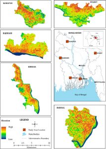
ABSTRACT: With little known and explored urban morphology in the fastest growing countries like Bangladesh in South Asia, this study aims at exploring urban spatial signature and explaining spatiotemporal land use and land cover patterns in the five cities (Rajshahi, Rangpur, Sylhet, Khulna, and Barisal) in Bangladesh. Using time series Landsat imagery, socioeconomic data and, other geospatial information with ecological analysis tools, this study quantifies and characterize the spatial-temporal landscape patterns and urban growth trajectory across the five selected sites. The spatial representation of these five sites demonstrates a continuous increase in urban/built-up areas replacing arable agricultural land, waterbodies, vegetation cover and wetlands, which thereby substantially altering the structure and function of the ecosystem surrounding the cities. Built up areas, representing impervious surface as observed from land cover maps in these five cities, are expanding quickly. The total built-up cover within the five cities grew from 2356 ha in 1973 to 13,435 ha in 2014 with a net increase of approximately 468%, while vegetation cover and crops field within same time period declined at 27.77% and 61.91%, respectively. This dramatic urban/built-up expansion has resulted in an increasingly faster alteration in the landscape composition causing to structural complexity at both class level and landscape level. Such rapid and unplanned urban expansion further has brought an overwhelming challenge to planners and policy makers, and has put a strain on local authorities to properly manage and utilize its limited land-based resources due to lack of time series geospatial information. The resulting thematic map and spatial information from this study is, therefore, to facilitate an understanding of urban growth dynamics and land cover change pattern in the five cities in Bangladesh. The result further can aid planners, stakeholders, and other interested groups to make the best possible choices regarding limited land-based resources to achieve an economically prosperous and environmentally sustainable future.
Read the full publication at Remote Sensing Applications: Society and Environment