With varying tangential winds and combinations of stratiform and convective clouds, tropical cyclones (TCs) can be difficult to accurately portray when mosaicking data from ground-based radars.
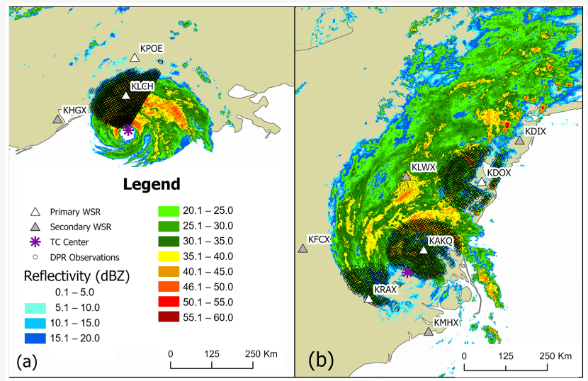
This study utilizes the Dual-frequency Precipitation Radar (DPR) from the Global Precipitation Measurement Mission (GPM) satellite to evaluate reflectivity obtained using four sampling methods of Weather Surveillance Radar 1988-Doppler data, including ground radars (GRs) in the GPM ground validation network and three mosaics, specifically the Multi-Radar/Multi-Sensor System plus two we created by retaining the maximum value in each grid cell (MAX) and using a distance-weighted function (DW).
We analyzed Hurricane Laura (2020), with a strong gradient in tangential winds, and Tropical Storm Isaias (2020), where more stratiform precipitation was present. Differences between DPR and GR reflectivity were larger compared to previous studies that did not focus on TCs. Retaining the maximum value produced higher values than other sampling methods, and these values were closest to DPR.
However, some MAX values were too high when DPR time offsets were greater than 120 s. The MAX method produces a more consistent match to DPR than the other mosaics when reflectivity is <35 dBZ. However, even MAX values are 3–4 dBZ lower than DPR in higher-reflectivity regions where gradients are stronger and features change quickly. The DW and MRMS mosaics produced values that were similar to one another but lower than DPR and MAX values.
Matyas, C. J., Zick, S. E., & Wood, K. M. (2025). Comparing Reflectivity from Space-Based and Ground-Based Radars During Detection of Rainbands in Two Tropical Cyclones. Atmosphere, 16(3), 307.