WILLIAMSON, ASH, MULLENS – Damages Associated with Excessive Rainfall Outlooks (ERO) and Missed Flash Floods
Meirah Williamson, Kevin Ash, Michael Erickson, Esther Mullens
Article first published online: 13 March 2023
DOI: https://doi.org/10.1175/WAF-D-22-0035.1
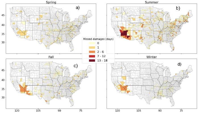
ABSTRACT: Flash flooding is the most damaging and deadly type of flooding event in the continental United States (CONUS), and one of the deadliest hazards worldwide. The Weather Prediction Center’s (WPC) Excessive Rainfall Outlook (ERO) is used to highlight regions at risk of receiving excessive rainfall that can lead to flash flooding. While EROs have been validated by the WPC across several metrics, an analysis of flash floods that were not forecast by EROs, which we define as missed flash floods, has not been performed, nor have damages associated with missed flash floods been examined. Using EROs, flash flood data from the Unified Flooding Verification System (UFVS), and flash flood damage data from the National Centers for Environmental Information (NCEI) Storm Events Database, this research investigates the characteristics of missed flash floods. We find that missed damages occur most frequently in summer and least frequently in winter, but that only 9.2% of flash flood damages and 23.2% of damaging events are missed by the ERO. Missed damaging flash flood events occur frequently in the Southwest US. In this region, missed damages and missed events are primarily attributed to the North American monsoon (NAM). We also investigate forecast flash floods by ERO risk category. High Risks incur the most damages despite having the fewest number of damaging events, indicating that the ERO is able to distinguish higher impact events. The ERO predicts damaging flash floods well, although the Southwest and urban areas broadly could be investigated further to ensure that the potential of damaging flash floods are accurately forecast.
Read the full publication in Weather and Forecasting.