MATYAS – Illustration of an Object-Based Approach to Identify Structural Differences in Tropical Cyclone Wind Fields
Stephanie Zick, Corene Matyas, Gary Lackmann, Jingyin Tang, Brian Bennett
Article first published online: 29 May 2022
DOI: https://doi.org/10.1002/qj.4326
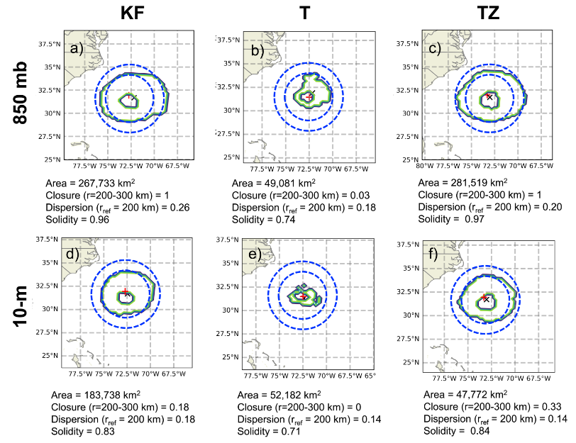
ABSTRACT: The meteorology community primarily assesses tropical cyclone (TC) forecast skill using track and intensity errors. These metrics are frequently uncorrelated and can offer conflicting information about model performance. Continued improvements in intensity forecasting requires improved representation of physical processes over multiple scales, and model verification of TC spatial structure can contribute to these improvements. To date, there are limited studies into forecast model representation of wind fields. More work is needed to better understand model deficiencies in skillfully predicting TC size metrics. In the current study, we demonstrate an object-based approach that can reveal structural differences in TC wind fields. Object-based methods have been under-utilized, and these methods, along with spatial metrics, can serve as additional verification methods for assessing storm structure in both observations and model simulations. Specifically, we illustrate this approach by examining a major difference between the Tiedtke and Kain Fritsch cumulus parameterization (CP) schemes: the Tiedtke scheme includes convective momentum transport (CMT) while the Kain Fritsch scheme does not. We create three experiments of Hurricane Isabel (2003) using the Weather Research and Forecasting model using the Kain-Fritsch and Tiedtke CP schemes and an altered Tiedtke scheme with CMT turned off. Within the three experiments, we generate a small ensemble of four simulations to avoid drawing erroneous conclusions due to growth of numerical noise. Then, we use object-based methods to measure and compare spatial attributes of the low-level wind fields to confirm the dominant influence of momentum transport in influencing the TC spatial structure. Our spatial metric approach offers an objective suite of structural attributes that could be useful in diverse applications. A future goal is to use spatial metrics in systematic verification studies of TCs in operational model forecasts and climate model simulations, which may offer great benefit to operational forecasters and numerical model developers.
Read the full publication in the Quarterly Journal of the Royal Meteorological Society.