WALTHER – Mapping travel time to assess accessibility in West Africa: The role of borders, checkpoints and road conditions
Olivier J.Walther, Lawali Dambo, Moustapha Koné, and Michiel van Eupen
Article first published online: 29 NOV 2019 Journal of Transport Geography
DOI: 10.1016/j.jtrangeo.2019.102590
ABSTRACT:
Distance, transport infrastructure and city networks
Accessibility remains problematic in many parts of West Africa. Due to sparse settlement patterns and a relatively new urbanisation process, West African cities are often separated by significant distances that increase transport costs and reinforce the marginalisation of remote regions (Naudé, 2009). Cities are also very unequally equipped with transport infrastructure that would increase accessibility (Olvera et al., 2013; Seedhouse et al., 2016; Oliete Josa and Magrinyà, 2018). Although most West African countries gained their independence close to 60?years ago, many cities are still not linked by paved road to the rest of the national networks. Accessibility also depends on the spatial distribution of the cities. Cities located a short distance from one another benefit from spillover effects that are difficult to reproduce in regions with a low level of urbanisation (Venables, 2010).
The poor accessibility of cities has major consequences for West Africa’s socio-economic development (Buys et al., 2010; Porter, 2014). Cities that are poorly connected to transport networks cannot serve as markets for local agricultural products and as hubs for regional trade (Dorosh et al., 2012; Walther, 2012; Ali et al., 2015). The products available in these cities are less numerous and diverse as well as more expensive than in towns that are more accessible (Teravaninthorn and Raballand, 2009). Poorly connected cities also provide less direct access to medical and educational services as well as cultural activities than do well-connected towns (Steck, 2012). In addition to undermining well-being, poor accessibility also underpins the regional integration agenda of West African regional bodies who work at facilitating trade from Dakar to N’Djamena (Turkson, 2018).
The crucial importance of accessibility has renewed international efforts to map travel time at the world level and assess how unequal access to cities affect livelihoods, education and health (Nelson, 2008; Weiss et al., 2018). Thus far, studies that map patterns of accessibility globally have focussed on large cities, which are particularly rare in West Africa, where 97% of urban areas have fewer than 300,000 inhabitants (OECD, 2019b). These studies also use global datasets that rarely account for the physical and institutional obstacles that can significantly reduce mobility in West Africa.
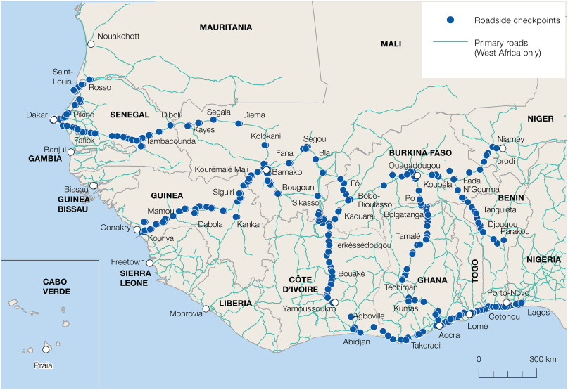
Our paper expands these global efforts by quantifying travel time required to reach the nearest city in West Africa, defined as a continuously built-up area of >10,000 inhabitants in 2015 (OECD, 2019b, OECD, 2019c). The originality of our work is to operationalise two regional features that, in addition to border delays, can potentially reduce accessibility in West Africa: roadside checkpoints, and road conditions. We first want to estimate what the potential population basins of border cities would be if border delays and checkpoints were removed. We then ask to what extent actual road conditions impact accessibility in border regions.
To answer these questions, we develop a model that measures the population that can theoretically be reached in under four hours by road from any West African city and apply it to all 245 cities located <20?km from a land border. Because road networks in the region promote national cohesion rather than regional integration (Debrie, 2010), these border cities offer a unique perspective on the current challenges of regional integration in West Africa (Salas-Olmedo et al., 2015).
Our analysis provides a first estimate of the impact of border delays, checkpoints and the state of deterioration of roads on the accessibility of West Africa. It shows that the accessibility of border cities could increase by 14% if there was no waiting at the borders in West Africa and by up to one-third in some regions. Our analysis also shows that removing roadside checkpoints would increase accessibility of border cities by 12% on average regionally and by more than half for some centres located on the Gulf of Guinea. Assessing how mobility is constrained by road obstacles in West Africa should contribute to highlight the current hurdle of corrupt practices and informal arrangements negotiated between state employees and private-sector actors along regional transport corridors.
Read the full publication at Journal of Transport Geography