 ALENEZI, GOOD, MEHEDY – Spatial pattern analysis of manufacturing industries in Keraniganj, Dhaka, Bangladesh
Mohammad Mehedy Hassan, Meshari S. Alenezi, Ryan Z. Good
Article first published online: 01 JAN 2019 GeoJournal
DOI: 10.1007/s10708-018-9961-5
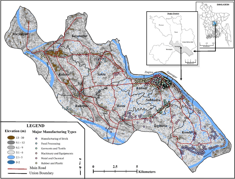
ABSTRACT: Understanding industrial clustering and its patterns of development are important steps in linking regional policy development, strategic decision making, business site management, and fostering a country’s economic growth. A considerable variety of common location-based cluster measures are available in practice, including area-based measures and a variety of indicators based on analyses of point data. This study uses the geostatistical approaches kernel density, multi-distance Reply’s-K, and spatial autocorrelation, both global Moran’s-I and local Moran’s-I, to assess the degree of spatial clustering of manufacturing locations in Keranignaj, located at the southern periphery of the urban region of Dhaka, Bangladesh. Results indicated a non-random pattern for all manufacturing locations in the study region. Small-scale industries such as garment manufacturing, metal, and brick making have a strong presence in Keranignaj. Expansion of such industries were highly associated with proximity to a river, while food processing, rubber and plastics manufacturing industries were clustered in relation to road proximity. The spatial association Global Moran’s-I with higher positive coefficient value indicates homogeneity, or spatial auto-correlation, exist in the industrial locations studied here. Local Moran’s-I, which documents regional clustering, has yielded a statistically significant manufacturing cluster (0.05 level) for the manufacturing areas of Zinjira, Kaliganj, Mirerbagh, and Chunkutia. Since cluster-based economic development has recently been an area of increasing interest for both developed and developing nations, the outcomes from this study provide an insight into spatial processes of industrial development in Bangladesh, and the Dhaka area in particular, enabling planners and policymakers to make rational, informed decisions and strengthening the economic growth and capacity for development of micro-industries clusters for the area studied here and the region beyond.
Read the full publication at GeoJournal